
Home » Posts tagged 'Ed Barnhart'
Tag Archives: Ed Barnhart
Adena and Hopewell: Advanced Indigenous Cultures of North America
Hopewell Ceremonial Earthworks – World Heritage Ohio
Honoring Native American Heritage Day — Indigenous Mound-Pyramid Builders the Adena and Hopewell Cultures
Today, November 27, 2020 is Native American Heritage Day in the United States. It’s the day after Thanksgiving and offers a different perspective on the indigenous peoples living across the northern continent. Contrary to popular colonial myth, the continent was widely settled far in advance of the Pilgrim’s arrival in 1620, and the southeastern cultures were particularly advanced hundreds of years earlier. The Adena and Hopewell civilizations lasting from 800 BCE to 500 CE were the first to build large cities and impressive earthworks in areas spanning the current states of Ohio, Kentucky, Indiana, and West Virginia. We do not know the names these indigenous peoples called themselves; Adena and Hopewell were given to them later based on local settlements in their regions.
At the same time as the height of Roman Empire (100-476 CE), there were thriving civilizations in North America. The extent of their trade network spans the eastern half of the United States, rivaling that of the Roman Empire. Massive earthwork enclosures built by these peoples are the largest collection on the planet, yet their construction still a mystery.
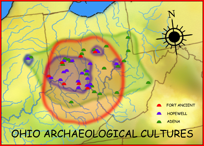
Map of Adena and Hopewell cultures. Wikimedia Commons, H. Rowe, 2008
Adena. Existing for about 900-1000 years, the Adena began mound building in central and southern Ohio regions. This evolved from prior practice of burying dead in piles of shells alongside rivers, including pet dogs, then moving to burials in large mounds of earth along with funerary objects such as jewelry, art, and ceramics. The Adena were notable for an extensive trading network which supplied them with copper from the Great Lakes to shells from the Gulf Coast. They developed agricultural practices, pottery, and artistic works although still living semi-nomadic lives and relying on hunting and gathering. Some Adena mounds—actually pyramids—were very tall and conical in shape, the highest being 65 feet tall at Miamisburg, Ohio. These pyramids were smooth on top and capped with clay, beginning as mortuary buildings which were ceremonially burned, then layers of burials placed on top followed by a new mortuary structure, and the process kept repeating.
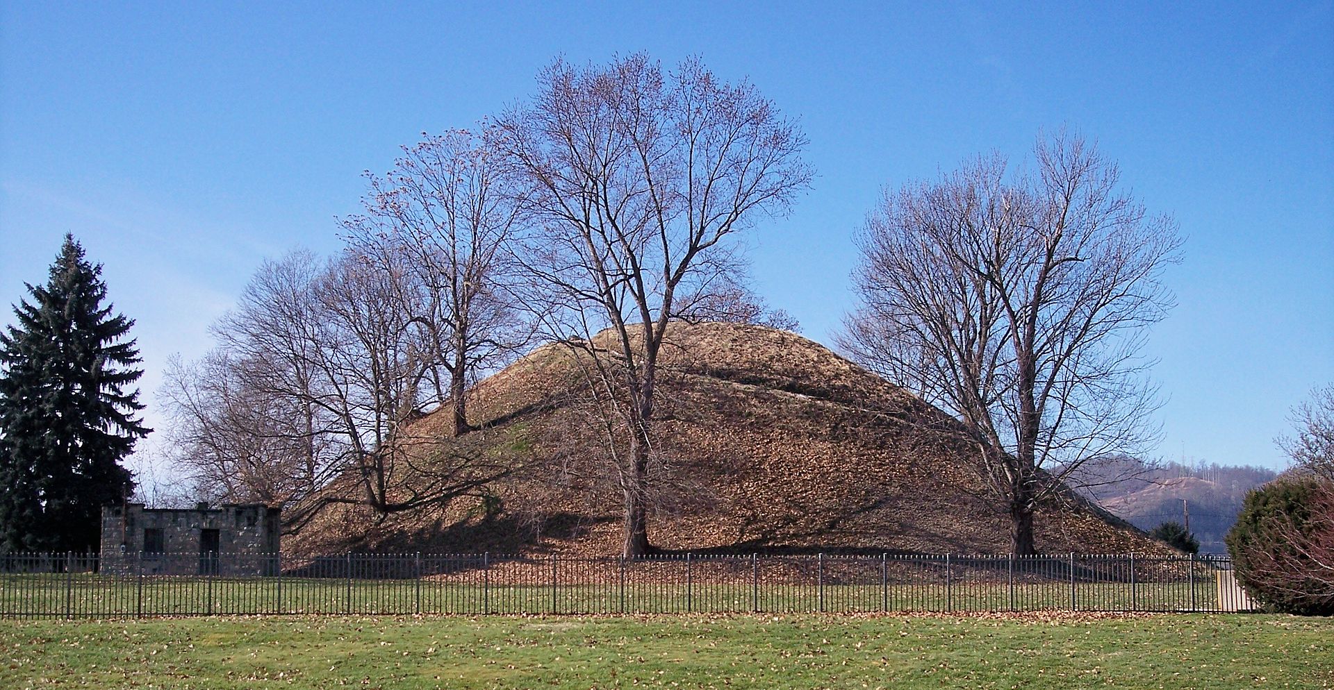
Grave Creek Mound, Adena Culture in Moundsville, West Virginia
62 feet tall, 240 feet diameter Wikimedia Commons, T. Kiser 2006
Adena people lived in small settlements of one to two structures; houses typically built in a circle ranging from 15 to 45 feet diameter. Walls were made of paired posts tilted outward, joined to other wood pieces to form a cone shaped roof covered with bark. The Adena had stone tools and axes, bone and antler tools, spoons and other implements. A few copper axes were found, but metal was generally hammered into jewelry such as bracelets, rings, and pendants.
Hopewell. Descendants of the Adena, Hopewell culture epicenter was Ohio starting at 100 BCE and lasting until 500 CE. Hopewell were masters of land survey and geometry, continuing the Adena custom of earthworks and mound-pyramids but vastly enlarging it. They extended the trade network from the Crystal River Indian Mounds in Florida to the northern shores of Lake Ontario, the Gulf Coast, and from the Mississippi River far to the east, but did not have much influence on the East Coast. From these regions they obtained mica, copper, shell, and soapstone. They produced beautiful artwork and made stone pipes in shapes of effigy animals, smoking tobacco and perhaps other substances.

Hopewell Interaction Sphere
Wikimedia Commons, H. Rowe, 2010
The name Hopewell came from mounds excavated in 1891-92 by Warren Moorehead at the property of Mordecai Hopewell in Ross County, Ohio. The Hopewell built earthworks in clusters of 10-20 mounds or more in same area. Once there were tens of thousands, but Hopewell mounds now only number in the hundreds due to encroaching development, both farmlands and towns. Many remaining earthworks are now preserved in parks and historic sites.
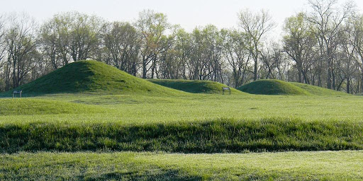
The great Hopewell geometric earthworks are among the most impressive indigenous monuments in the U.S. They take various geometric shapes and rise to amazing heights, often shaped like animals, birds, or serpents. There are gigantic enclosures bounded by berms of earth that are 20 feet wide by 20 feet tall. These often covered 20 acres (15 football fields); and could hold 17 pyramids of Giza inside. Some reached 50 acres and the largest is 111 acres at the Hopewell site. Maps and drawings made in the 1840s document earthworks, many that are now destroyed, but some have been preserved at the Hopewell Cultural Historic Park.

Model of Hopewell Ceremonial Earthworks, Newark
World Heritage Ohio
Mystery of Massive Earthworks. An impressive level of coordination was needed to build all these earthworks, spread over a large region and using the same geometric principles and formulas. One repeated measurement is 1053 feet, appearing in different parts of structures—some square, rectangular, octagon. Many areas have enclosures of 20 acres, and squaring the circle or circling the square was used repeatedly. Hopewell structures were built so measurements of a square fit inside a circle and vice versa. Such repetition shows that there was clear intentionality in building. But who organized the labor forces to build massive geometric earthworks?
Hopewell villages were small and the people did not live near the earthworks. Villages were a few miles away, rarely had more than 100 people, houses were simple rectangular (occasionally circular) shapes made of wattle-and-daub with grass roofs, holding 1-2 families. Diet was simple, with small scale agriculture augmented by hunting and fishing. They did not have corn, cultivating native plants like pigweed, sunflowers, maygrass, and goosefoot. These were egalitarian settlements without large differences between houses denoting different social status. There is no evidence of a chief or ruling class. There was some class differentiation seen in burial placements inside mounds and amount/types of burial artifacts. The largest burial mound is at the Hopewell site, three interconnected structures 500×180 feet, and 30 feet tall at the base. Following Adena practices, these mounds started as mortuary structures, then were burned and burials put on top, taking place over years and decades. The most elaborate burials were in the center, the earliest phases. Multiple burials were interred at once; bodies must have been stored for a while before being interred. Group burials were not due to war and there is no evidence of violence or warfare in Hopewell archeology. Burial pyramids grew in size over time, then were capped with hard surface and temples built on top.
Hundreds of workers were needed, along with persuasive leaders to accomplish these works, but archeological evidence shows only small egalitarian villages. According to archeologist Edwin Barnhart‘s theory, these small, peaceful villages banded together to create the earthworks, probably as gathering places for celestial timed ceremonies. Building the earthworks in itself was the ceremonial event. They gathered together every decade or two, timed to lunar events, as a single people to create something great and enduring. Such shared effort in raising monuments is powerful builder of community. (ArchaeoEd Podcast Episode 3 – The Hopewell)

Model of Hopewell Earthworks at Fort Ancient, Ohio
World Heritage Ohio
Astronomical Aspects of Hopewell Earthworks. Hopewell earthworks encode knowledge of astronomy focusing on solar system objects; known as “horizon based astronomy.” This takes note of the rise and set of the sun, moon, and planets, all visible to the naked eye. The Hopewell made solar and lunar observations, and several earthworks align to winter or summer solstice: Hopeton, Dunlap, Anderson, Mound City, and Hopewell site all have solar alignments through diagonals, not sides of the squares. At times they had to make adjustments for mountains; the Marietta site has mountain ridges so they used astronomical knowledge and land survey techniques to compensate in aligning with solstice.
Octagon sites at Newark and High Bank did not have solstice alignments, but instead followed movements of the moon. The many angles of the Newark octagon captured all lunar alignments. Lunar maximums (maximum excursion along the horizon) occur every 18.6 years at full moon. This moon cycle of lunar maximums and minimums was captured by Hopewell. It takes years to determine this; there are 4 such alignments in a full cycle, 2 maximum and 2 minimum. Different lunar alignments were used at the High Bank site octagon.
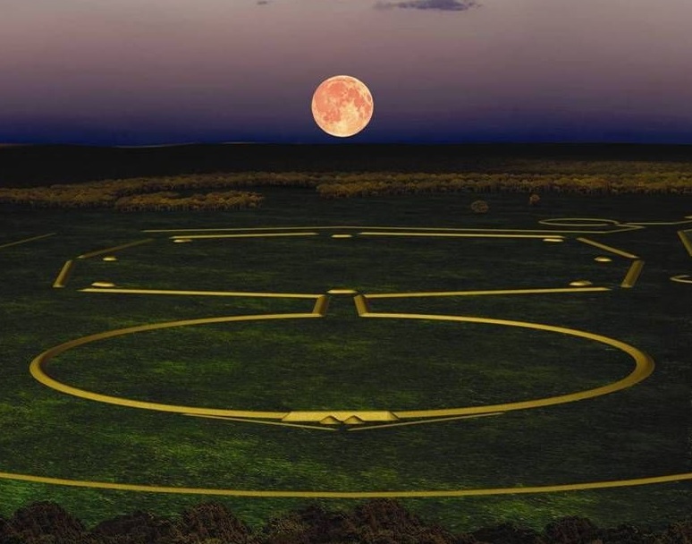
Lunar rise above octagon-circle earthworks, Hopewell site, Ohio
World Heritage Ohio
Lunar Aligned Earthworks at Newark Ohio. This spectacular lunar alignment at the Hopewell site in Newark, Ohio (built between 100 BCE – 300 CE) includes the 1200-foot-diameter Great Circle with its steep inner ditch and monumental framed gateway, plus the Octagon Earthworks, forming a perfect circle and adjoining octagon over a half-mile across. The perfectly formed, eye-level embankments align with all eight of the key rise- and set-points of the moon during its 18.6-year cycle, within a smaller margin of error than that at Stonehenge. World Heritage Ohio.
Cultural decline: Around 500 CE, the Hopewell stopped building mounds and earthworks, their trade exchange ended, and their art was no longer produced. Rising hostility is a possible cause, since villages at the end of the Hopewell period became larger communities that built defensive walls and ditches. Climate change with colder conditions probably drove game animals north or west, and had detrimental effects on plants, drastically reducing these food sources. The bow and arrow were introduced during this time, improving hunts but further depleting game. This effective weapon made warfare more deadly, driving people into larger fortified communities. With fewer people using trade routes, the network linking people to the Hopewell traditions diminished. Full-scale agriculture after introduction of corn might also have contributed to breakdown of social organization. Conclusive reasons for the dispersal of these prodigiously creative people have not yet been determined. (Wikipedia, Hopewell Tradition)
El Mirador Adventure
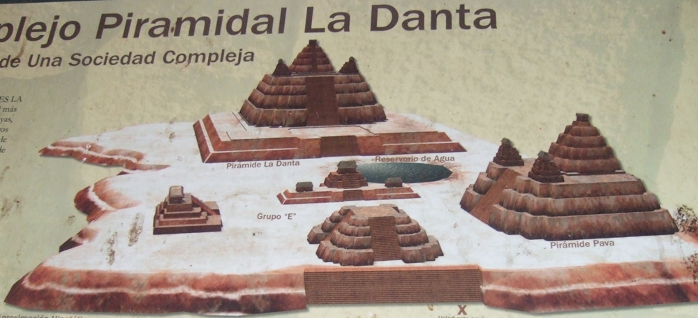
La Danta complex at El Mirador
Most Maya enthusiasts harbor the desire to visit El Mirador, a Pre-Classic site in northern Guatemala. Few ever do it, however, because getting there is arduous. El Mirador is located in the heart of a large swath of undisturbed low-lying jungle called the Mirador Basin in the Mirador-Río Azul National Park. This large tract of sub-tropical jungle is full of bajos or low wetlands with surrounding marshes, and no roads give access to its interior. The nearest town, Carmelita, sits at the end of a long dirt road. It takes three days of travel on narrow paths by foot or mule to reach the site, braving rains, mud, mosquitoes, snakes and jaguars. Most visitors come by helicopter, a thirty-minute flight from the town of Flores on Lake Petén Itza. This remote region is within the Maya Biosphere Reserve, 8100 square miles of protected rain forests designated by the Guatemalan government and supported by many groups to prevent deforestation, destruction and looting of ancient Maya sites.
Prudently, our group of ten intrepid Maya enthusiasts opted for helicopters over mule train. Led by Dr. Edwin Barnhart of the Maya Exploration Center, we flew over the rolling canopy of trees including

Helicopters landing in small clearing
ramón (breadnut), ceiba, mahogany, copal and sapodilla, some growing to 150 feet. Once beyond the reserve edge, cleared fields used for crops and cattle gave way to an unbroken sea of dense foliage, punctuated by what seemed to be hills, but were the tree-covered peaks of ancient pyramids. When we reached the tallest pyramids, whose stone tops protruded beyond the canopy, the helicopters circled for landings at the sites we were visiting: Nakbe, El Mirador and El Tintal. With military precision, the pilots hovered over small clearings nearly undetectable until you were right over them, and settled the helicopters down.
For most of us, this was the trip of a lifetime. All students of the ancient Mayas, we knew El Mirador was among the oldest Maya cities, possibly the largest, often called the “Cradle of Maya Civilization.” Although abandoned over 2000 years ago, there are tantalizing hints that the people of El Mirador may have migrated to the Caribbean coast then back inland to settle at Kalakmul, a powerful rival to Tikal in the sixth and seventh centuries. Mirador was known as the “Kan Kingdom” in the Pre-Classic, and the rulers of Kalakmul said they were Lords of Kan.
The Mirador Basin was home to numerous Pre-Classic Maya cities that might have supported a population close to a million people.(1) The oldest city, Nakbe, was likely occupied before 800 BCE, with clear evidence of occupation by 600 BCE. El Mirador, the largest city, flourished between 300 BCE and
Map of El Mirador
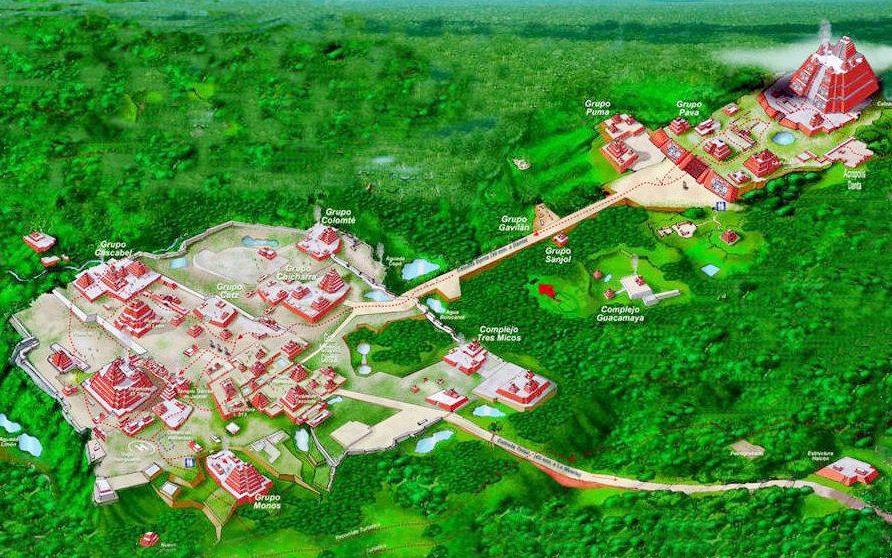
150 CE with a peak population over 100,000. Its central area covers 10 square miles with several thousand structures, and its pyramids reach 180-230 feet high and include “La Danta,” among the largest pyramids in the world with its total volume of 99 million cubic feet. The second largest city, El Tintal, was occupied during this same time period. Its central area covers 3.5 square miles with nearly 1000 structures and several pyramids, the tallest 160 feet.
These three cities were linked by raised roadways called “sacbeob” built of stone and plaster, creating a network of white causeways through the jungle. Within each city, sacbeob led from one complex to another, providing a level walkway rising 18-20 feet above ground level and some 60-150 feet wide. The remnants of these causeways still provide level walking surfaces, now traversed by tree roots but cleared of brush by site workers.
The primary archeological work in Mirador Basin is conducted by Dr. Richard Hansen of Idaho State University. Beginning in 2003, his team initiated investigation, stabilization and conservation programs with a multi-disciplinary approach involving 52 universities and research institutes. The ruined city had been recorded and photographed in 1926-1930, but its remote and inaccessible location deterred much investigation, with Ian Graham making the first map in 1962 and Ray Matheny excavating the site center in the 1980s. The archeologists were surprised to find construction that was not contemporary with the
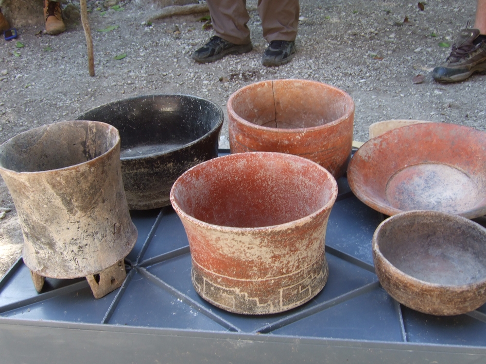
Pottery found at El Mirador
large Classic cities in the area, such as Tikal and Uaxactun, but from earlier centuries. Pottery fragments collected by Joyce Marcus in 1970 and others found by Richard Hansen in 1979 were identified as Chicanel style, a monochrome red, black or cream with turned-out rims and a waxy feel. This pottery had been dated to Late Pre-Classic (300 BCE – 150 CE).
Finding complex cities with immense platforms, tall pyramids and royal compounds that were dated to Pre-Classic times caused a shift in thinking about Maya civilization. The Mayas had a high culture and sophisticated social structure far earlier than was previously believed. Speculation about the source of Maya kingship systems that produced such monumental architecture include diffusion from Zoque-Olmec centers such as La Venta and Chiapa de Corzo, as well as cultural interaction with other Maya centers to the west. Multiple opportunities for cultural borrowing and lending raise the question of who borrowed what from whom.(2)
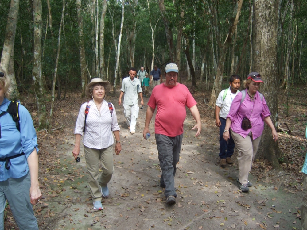
Walking on sacbe at El Mirador with archeologist Ed Barnhart (red shirt)

Sunset from top of El Tigre pyramid
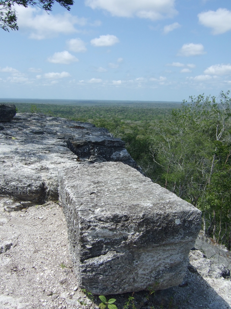
As our group walked the wide tree-shrouded paths, we saw tall mounds of tumbling rocks rising through the foliage, and were amazed at the size and number of structures. Several complexes in El Mirador were partially cleared and restored, giving provocative views into this ancient culture that left no writing yet discovered. A central complex held several tall pyramids including El Tigre and its two flanking pyramids forming a triad group, with the Monos and Leon pyramids farther away. We climbed rickety stairs to the stony top of El Tigre and watched a spectacular tropical sunset. A five-mile round trip trek from our camp brought us to La Danta, gradually ascending over several levels of plazas covering nearly 45 acres. The platform supporting La Danta is 980 feet wide and 2000 feet long. Although the actual pyramid summit did not seem dauntingly tall once we arrived at its final platform, we kept remembering all the previous levels we had ascended. La Danta stands 230 feet, taller than Temple IV at Tikal. Though not as tall as the Great Pyramid of Khufu in Egypt, it is larger in volume at 99 million cubic feet.
Climbing switchback wooden stairs with handrails, we ascended to the top of La Danta and gazed across miles of jungle stretching 360 degrees to all horizons. A light wind cooled our over-heated bodies as we rested thankfully on large square stones. Two geodesic markers gave coordinates for the summit. In the distance the mounds of Nakbe and La Tintal were visible as forested hills. It was heady to be standing atop the reputed largest pyramid in the world. A sense of the expanse and inter-connectedness of the ancient Maya world created feelings of awe.

Stairs to La Danta platform
La Danta summit view across jungle

Standing on La Danta summit
The most important artwork found at El Mirador is the Central Acropolis frieze. In 2009 a student named J. Craig Argyle uncovered two 26-foot carved stucco panels that had been covered over by another structure. Their burial inside this structure, filled with dirt and crumbled stone, preserved this beautiful creation that depicts two young men in the “swimming god” posture. Above them are two bird figures, one a cormorant and the other a human-faced macaw. Richard Hansen believes the frieze relates Popol Vuh mythology, showing the Hero Twins, one wearing the jaguar headdress containing the head of his father. The Twins descended into Xibalba, the Underworld, to defeat the Death Lords and resurrect their father (Hun Hunahpu, First Father of the Mayas). The cormorant signifies rulership lineages and links to Great Mother Goddess Muwaan Mat (Duck-Hawk/Cormorant). The human-faced macaw represents the False Pole Star Wuqub Kaquix, an arrogant macaw who tried to become a god. The Hero Twins shot him from a tree with their blow-gun, unseating his lordship.(3)

Central Acropolis Frieze
Composite View
Finding this depiction of the Popol Vuh myth in a Pre-Classic site proves that the story has great antiquity and predates contact with Spanish Christianity by thousands of years. Contact-era renditions of the Popol Vuh were thought to be influenced by Christian imagery. Ed Barnhart questions whether the frieze actually depicts the Popol Vuh, because key elements that signify the Hero Twins, such as jaguar spots and catfish barbels, are missing. However, we know the Popol Vuh was well-established early in Maya mythology from murals discovered in San Bartolo, Guatemala, dated to 100 CE that also portray scenes from this story.(4)
Tent camp rigors
To see these fantastic carvings and other artifacts, to climb the pyramids that soared above the jungle canopy, to walk the pathways trod by ancient Mayan feet in times long past, required commitment and dedication. Conditions in our tent camp in El Mirador were primitive, without electricity or running water, and without showers. Our guide Ed Barnhart arranged for everything we needed to be brought by

Ocellated turkey
mule train, a 5-hour trek along a jungle path from Carmelita. The mules packed in all our drinking and cooking water, food, drinks, tents, bedding and implements. A staff of two cooks, two local guides, and four carriers attended us. Our meals were surprisingly good, cooked over fires in primitive conditions. The Mayan woman cook made delicious traditional tortillas and provided meals of rice, chicken, vegetables, black beans, eggs, pancakes, fruit and cereal. We drank from water bottles, using iodine to purify the larger water tanks when we ran out of bottles. Refreshing limeade accompanied meals; at

Camp hand washing station
times we resorted to luke-warm gatorade when the ice melted. A hand washing station with suspended dishrag and soap dispenser served well; we had several tarp-enclosed outhouses and a tarp-covered picnic table. In our tent area, three hammocks suspended from trees offered afternoon respite.

Hammocks and tent camp
Unseasonal rains occurred before we arrived, so the first day was fresh and less hot. Hot is the operative word; the next several days were roasting and muggy. Everyone got very sweaty, especially as we wore long sleeve shirts and long pants with closed shoes to prevent bites. There were far fewer bugs than expected; our guides said “three mosquitoes per person” but an abundance of spiders, gnats, moths, ants, and crickets. Very large, black cicadas serenaded us dusk and dawn, making an ear-splitting high whine. A flock of ocellated turkeys hung around camp, their iridescent feathers shining. The male’s deep popping noises started at 4:00 am, along with the roars of howler monkeys that are often mistaken for jaguars, which actually make grunting noises. Though some folks were concerned about the deadly fer-de-lance snake (called yellow jaw) our guides said rattlesnakes are much more common. The only snake we saw was a small dead one, possibly a fer-de-lance.
Sleeping in tents on air or foam mattresses was far from comfortable, especially the last two nights that were oppressively hot. A generator provided light until 9:00 pm at the kitchen and meal area, and around our tent camp hammocks. Trips to the outhouse required using flashlights and keeping an eye out for snakes and bugs. We were up at dawn, thanks to the turkey and howlers, and eager for our first

About to climb Nakbe pyramid
cup of coffee – surprisingly good instant called “Inka-mundo.” Taking advantage of the morning for our first excursion, we hit the sacbeob early and were out around 2-3 hours, using lots of energy walking and climbing. We’d return for lunch and a siesta, then make another trip to the site late afternoon. At Nakbe and El Tintal, we spent about 2 hours while the helicopters waited. Upon returning to Flores, the first thing everyone did was take a long shower, do some email or texting, then get a cold margarita or beer!

Back in Flores enjoying margaritas
Our group of adventurous souls was uncomplaining about creature discomforts and deeply appreciative of this great opportunity to visit a remote Maya site of vast significance. The impressive size and number of cities with their monumental and residential structures, located in a nutrient-rich swampy region, led our imaginations to picture the area at its height: people streaming along wide sacbeob, using sophisticated techniques to quarry huge limestone blocks without metal tools, move them to building sites without wheels and lift them to amazing heights, interacting in complex class societies with a cohesive ideology, performing splendid rituals, producing striking carved art and ceramics, collecting rainwater in cisterns, using body decoration such as inlaid jade in teeth and skull shaping, and using imported objects such as seashells, obsidian and basalt.
Between 100-200 CE, the cities of Mirador Basin were abandoned. The people apparently left quickly, leaving ceramics and working tools where they were used. Hansen believes the exodus was caused by destruction of the swamps that supported their agriculture. Massive deforestation in surrounding areas to provide wood for making lime plaster may be the underlying cause. In El Mirador they plastered everything from temples and plazas to sacbeob and house floors, making the plaster thicker over time. The reason, says Hansen, was “conspicuous consumption” by elites trying to sustain an image of wealth and progress. Clay drained from forests into the swamps and covered the rich soil. A portion of El Mirador was temporarily re-occupied in the Late Classic, around 700-900 CE, with small structures built among the ruins. Here the occupants, probably scribes
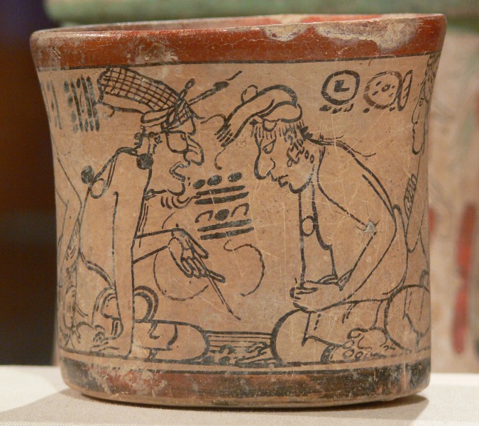
Maya Codex style ceramic
and artists from Kalakmul, produced unique “Codex-style” ceramics, fine polychrome ceramic consisting of black line drawings on a cream colored background. This was beyond doubt the trip of a lifetime. It was not easy, but it was rich in learning and experiencing

Ed Barnahrt and Lennie Martin, La Danta summit
the residuals of a once-great culture that flourished then declined, leaving many unanswered questions. For Maya enthusiasts, it stimulates further research into the mysteries of the Pre-Classic, seeking to understand how kingship structures and class societies came into being, the power and trade relationships among sites, the stories of the residents and their lives.
References
- Chip Brown. El Mirador, the Lost City of the Maya. Smithsonian Magazine, May 2011.
- John E. Clark and Richard D. Hansen. The Architecture of Early Kingship: Comparative Perspectives on the Origins of the Maya Royal Court. Royal Courts of the Ancient Maya, Vol. 2. Edited by Takeshi Inomata and Stephen D. Houston. Westview Press, Boulder, CO, 2001.
- Dennis Tedlock. Popol Vuh. Touchstone Book, Simon & Schuster, New York, 1996.
- William A. Saturno, David Stuart, Boris Beltrán. Early Maya Writing at San Bartolo, Guatemala. Sciencexpress Report, January 5, 2006.
Leonide (Lennie) Martin writes historical fiction about ancient Mayan civilization. Visit website at Mists of Palenque.
